Atmosphere Layers, Gaseous Composition and Cloud Types
Why do We Need the Atmosphere?
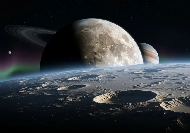
When you look up at the sky, you see blue, white, or sometimes a fiery orange at sunset. All of these colors and the weather you experience—rain, wind, sunshine, snow—come from a thin blanket of gases that wraps around our planet: the atmosphere.
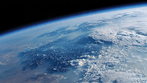
Even though the atmosphere is only about 100 kilometers (62 miles) thick compared to Earth’s radius of roughly 6,371 kilometers, it does three crucial jobs:
- Provides the air we breathe – mainly oxygen (O₂) for our cells.
- Protects us from harmful solar radiation – especially ultraviolet (UV) rays that can damage DNA.
- Regulates temperature – trapping just enough heat to keep the planet livable (the greenhouse effect).
Understanding how the atmosphere is built—its layers, what gases it contains, and how clouds form—helps us make sense of weather forecasts, climate change, and even why airplanes fly at certain heights.
The Five Main Layers of the Atmosphere
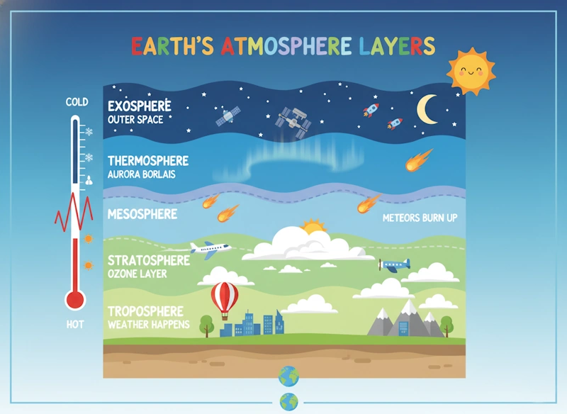
Scientists split the atmosphere into five primary layers based on how temperature changes with altitude. Imagine stacking five different blankets, each with its own “feel” (temperature trend) and special features.
| Layer (from bottom to top) | Approx. Height Range | Temperature Trend | Key Features |
|---|---|---|---|
| Troposphere | 0 – 12 km (0 – 7.5 mi) | Decreases with height (about -6.5 °C per km) | Where we live, weather happens, most water vapor |
| Stratosphere | 12 – 50 km (7.5 – 31 mi) | Increases with height (ozone absorbs UV) | Contains the ozone layer; jet streams fly here |
| Mesosphere | 50 – 85 km (31 – 53 mi) | Decreases with height (coldest part) | Meteors burn up; noctilucent clouds appear |
| Thermosphere | 85 – 600 km (53 – 373 mi) | Increases with height (solar energy heats particles) | Auroras; International Space Station orbits here |
| Exosphere | 600 km – 10,000 km (373 – 6,200 mi) | Very thin; particles can escape to space | Gradual transition to outer space; satellites |
Below each layer is described in more detail, using everyday analogies to make the concepts stick.
Troposphere – Our “Weather Kitchen”
- What you feel: If you’ve ever stood on a mountain and noticed it’s colder than at sea level, you’ve felt the troposphere’s temperature drop.
- Why it matters: Almost all weather—clouds, rain, snow, thunderstorms—occurs here because this layer holds ≈ 99 % of the atmosphere’s water vapor and ≈ 75 % of its total mass.
- Typical height: At the equator the troposphere can reach ~ 18 km because warm air expands; at the poles it’s only ~ 8 km thick.
- Interesting fact: The top of the troposphere is called the tropopause. Commercial airplanes usually cruise just below or in the lower stratosphere to avoid turbulence, but they often fly in the upper troposphere on shorter routes.
Stratosphere – The “Ozone Shield”
- Temperature flip: Unlike the troposphere, the stratosphere gets warmer as you go up. This happens because the ozone (O₃) layer absorbs the Sun’s harmful ultraviolet radiation, turning that energy into heat.
- Ozone layer: Concentrated between ~ 20 km and ~ 30 km, ozone acts like a sunscreen for Earth. Without it, life would be exposed to dangerous UV levels that can cause skin cancer and harm phytoplankton (the base of ocean food chains).
- Jet streams: Fast, narrow rivers of air flow near the bottom of the stratosphere (around 10-12 km). Pilots use them to save fuel on long flights.
- No weather: Because the temperature increases with height, the air is stable; there’s little vertical mixing, so you don’t see clouds or storms here.
Mesosphere – The “Meteor Burn‑Zone”
- Coldest place: Temperatures can drop to -90 °C (-130 °F) near the top, making it the coldest atmospheric layer.
- Meteors: When space rocks enter Earth’s atmosphere, they travel so fast that friction with air molecules heats them up. Most burn up completely in the mesosphere, creating the bright streaks we call “shooting stars.”
- Noctilucent clouds: Very thin, ice-crystal clouds that appear near 80 km altitude during summer months at high latitudes. They shine after sunset because they’re still illuminated by the Sun while the ground is dark.
Thermosphere – The “Hot, Thin Upper Sky”
- Temperature rise: Though it sounds contradictory, the thermosphere can reach over 1,500 °C (2,700 °F) because individual gas molecules absorb a lot of solar energy. However, the air is so thin that “temperature” here doesn’t feel hot to a human—you would not feel heat because there are hardly any molecules to transfer energy to your skin.
- Auroras: Charged particles from the Sun (the solar wind) collide with oxygen and nitrogen molecules, exciting them. When they relax, they emit light—creating the beautiful northern and southern lights (aurora borealis and australis).
- Space travel: The International Space Station (ISS) orbits at about 400 km, well inside the thermosphere. Despite the high temperature, the ISS experiences very little drag because the air density is extremely low.
Exosphere – The “Gateway to Space”
- Almost a vacuum: Particles are so sparse that they can travel hundreds of kilometers before colliding with another atom. Some light gases (hydrogen, helium) achieve enough speed to escape Earth’s gravity entirely, drifting into space.
- Satellites: Many weather and communications satellites reside in the exosphere because they need minimal atmospheric drag to stay in orbit for years.
- No clear boundary: The exosphere fades gradually into interplanetary space; scientists define its outer edge where the influence of Earth’s gravity becomes negligible compared to the Sun’s.
The Gases That Make Up the Atmosphere
Even though the atmosphere looks like a uniform “sky,” it’s a mixture of many gases. The composition is remarkably stable over short periods (days to years) but has changed dramatically over geological time.
Major Gases (by volume)
| Gas | Symbol | Approx. Percentage (by volume) | Role in the Atmosphere |
|---|---|---|---|
| Nitrogen | N₂ | 78 % | Dilutes oxygen; relatively inert; important for plant growth (via nitrogen fixation) |
| Oxygen | O₂ | 21 % | Essential for respiration in animals and many microorganisms; supports combustion |
| Argon | Ar | 0.93 % | Inert noble gas; used in light bulbs and welding |
| Carbon Dioxide | CO₂ | 0.04 % (≈ 410 ppm) | Greenhouse gas; vital for photosynthesis |
| Neon, Helium, Methane, Krypton, Hydrogen, Xenon | Various | Trace (< 0.01 % each) | Have specialized roles (e.g., methane is a potent greenhouse gas; helium used in balloons) |
Percentages are based on a dry atmosphere. Water vapor (H₂O) is variable—from near 0 % in cold, dry air up to about 4 % in hot, humid tropical air—and is not included in the above table because it fluctuates constantly.
Why Nitrogen Dominates
Nitrogen molecules are very stable; they don’t readily react with other substances under normal conditions. Early Earth’s volcanic outgassing released lots of nitrogen, and because it isn’t easily removed by chemical reactions or biological processes (except through nitrogen-fixing bacteria), it accumulated to become the bulk gas.
Oxygen – The Breath of Life
Free oxygen didn’t appear in large amounts until photosynthetic microbes (like cyanobacteria) began splitting water and releasing O₂ as a by-product, roughly 2.4 billion years ago (the Great Oxidation Event). Today, plants and phytoplankton replenish the oxygen we use through photosynthesis:
6\text{CO}_2 + 6\text{H}_2\text{O} \xrightarrow{\text{light}} \text{C}6\text{H}{12}\text{O}_6 + 6\text{O}_2
Argon – The Quiet Noble Gas
Argon is produced by the radioactive decay of potassium-40 in the Earth’s crust. It seeps out slowly and accumulates in the atmosphere. Because it doesn’t react, it’s useful as a protective gas in welding and in filling double-pane windows to improve insulation.
Carbon Dioxide – The Climate Regulator
Though only 0.04 % of the atmosphere, CO₂ has a huge impact on temperature because it absorbs infrared radiation (heat) emitted by the Earth’s surface. Human activities—burning fossil fuels, deforestation, cement production—have raised CO₂ from about 280 ppm (pre-industrial) to over 420 ppm today, enhancing the greenhouse effect and driving global warming.
Trace Gases with Outsized Influence
- Methane (CH₄): About 1.9 ppm; over a 20-year period, it traps ~ 84 times more heat per molecule than CO₂. Sources include wetlands, livestock, landfills, and natural gas leaks.
- Nitrous Oxide (N₂O): ~ 0.33 ppm; a potent greenhouse gas and also involved in ozone depletion.
- Ozone (O₃): Found mainly in the stratosphere (the ozone layer) but also a pollutant near the surface (smog). In the stratosphere it protects us; in the troposphere it irritates lungs and damages plants.
Water Vapor – The Variable Greenhouse Player
Water vapor is the most abundant greenhouse gas, but its amount changes constantly with temperature and location. Warm air can hold more water vapor; cold air holds less. This relationship is described by the Clausius-Clapeyron equation, but for our purposes, think of it like a sponge: a warm sponge can soak up more water than a cold one.
- Typical values:
- Polar winter air: < 0.1 %
- Mid-latitude summer air: ~ 1-2 %
- Tropical air: up to ~ 4 % (rarely exceeds this because condensation limits it)
When water vapor condenses into liquid droplets or ice crystals, it releases latent heat, which fuels thunderstorms and drives the hydrologic cycle (evaporation → condensation → precipitation → runoff).
Clouds – Visible Signs of Water in the Atmosphere
Clouds are collections of tiny water droplets or ice crystals suspended in the air. They form when air containing water vapor cools to its dew point (the temperature at which the air becomes saturated) and the excess vapor condenses onto microscopic particles called condensation nuclei (dust, salt, smoke).
How Clouds Form – A Simple Story
- Air rises – due to heating from the ground (convection), being forced up a mountain (orographic lift), or meeting a front where warm air rides over cold air.
- As it rises, pressure drops, so the air expands and cools (adiabatic cooling).
- When cooled enough, the water vapor reaches saturation and condenses.
- Droplets or crystals gather around nuclei, becoming visible as a cloud.
If the temperature is below freezing, the water may deposit directly as ice (called deposition), forming ice-crystal clouds.
Cloud Classification – The “Three-Level” System
Meteorologists sort clouds by altitude (high, middle, low) and shape (layered vs. convective). The system was first established by Luke Howard in 1802 and remains the basis for today’s cloud charts.
| Cloud Level | Typical Base Height | Cloud Types (with symbols) | Appearance & Weather Clues |
|---|---|---|---|
| High Clouds (5-13 km) | 5 km – 13 km (16,000-43,000 ft) | Cirrus (Ci) – thin, wispy Cirrostratus (Cs) – sheet-like, often halo Cirrocumulus (Cc) – small, white patches | Usually indicate fair weather; thickening cirrus can signal an approaching warm front. |
| Middle Clouds (2-7 km) | 2 km – 7 km (6,500-23,000 ft) | Altostratus (As) – gray/blue-gray veil Altocumulus (Ac) – white/gray patches, sometimes “sheep-back” | Altostratus often precedes steady rain; altocumulus can signal thunderstorms if they grow vertically. |
| Low Clouds (0-2 km) | 0 km – 2 km (0-6,500 ft) | Stratus (St) – uniform gray layer, often fog when touching ground Stratocumulus (Sc) – low, lumpy rolls Nimbostratus (Ns) – thick, dark, rain-bearing Cumulus (Cu) – fluffy, cotton-like, flat base Cumulonimbus (Cb) – towering, anvil-topped thunderstorm cloud | Stratus = overcast drizzle; stratocumulus = mild weather; nimbostratus = continuous rain/snow; cumulus = fair weather (if small) or developing thunderstorms (if tall); cumulonimbus = heavy rain, hail, lightning, tornadoes. |
Specialty Clouds (based on unique formation processes):
- Fog: A stratus cloud whose base is at ground level. Forms when moist air cools near the surface (radiation fog) or when warm moist air moves over a cold surface (advection fog).
- Lenticular Clouds: Lens-shaped, stationary clouds that form on the downwind side of mountains when stable air flows over a peak and creates standing waves.
- Mammatus Clouds: Pouch-like protrusions hanging under the base of a cumulonimbus; indicate severe turbulence.
- Noctilucent Clouds: Highest clouds (≈ 80 km), made of ice crystals in the mesosphere; visible at twilight in polar summer.
- Polar Stratospheric Clouds (PSCs): Form in the extremely cold winter stratosphere; play a role in ozone depletion chemistry.
Why Clouds Look White (or Gray)
Cloud particles are about the same size as the wavelength of visible light, so they scatter all colors almost equally (Mie scattering). When many droplets scatter light in all directions, the combined light appears white. If the cloud is thick, less sunlight makes it through to the bottom, so the base looks gray or dark—a sign that the cloud is holding a lot of water and may soon precipitate.
Clouds and the Weather Cycle
- Cumulus → Cumulonimbus: On a sunny day, surface heating creates rising thermals. Small cumulus clouds form; if the updraft stays strong and moist, they can grow vertically into towering cumulonimbus, producing thunderstorms.
- Stratus → Nimbostratus: When a large air mass is lifted gently over a wide area (like a warm front), a broad stratus layer forms. If the layer deepens and cools enough, it becomes nimbostratus, bringing steady rain or snow.
- Cirrus as a Forecaster: High, thin cirrus often appears 12-24 hours before a warm front arrives, signaling a change in weather.
Bringing It All Together – A Day in the Life of the Atmosphere
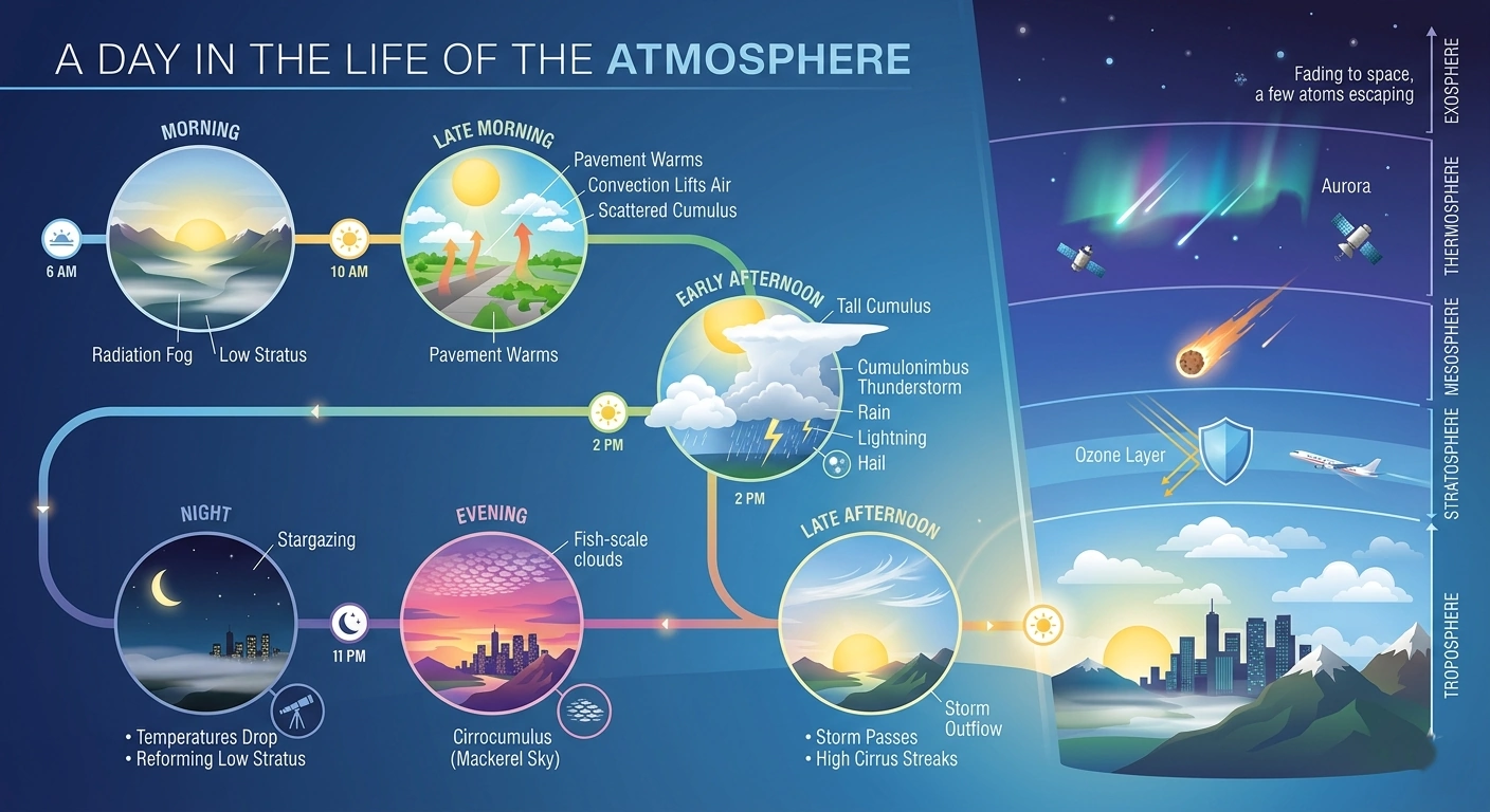
Imagine a typical spring day in a mid-latitude city:
- Morning: The ground is still cool; a thin radiation fog (a low stratus cloud touching the surface) may linger in valleys.
- Late Morning: Sun warms the pavement; convection lifts moist air, forming scattered cumulus clouds over parks.
- Early Afternoon: If the day is especially warm and humid, some cumulus grow taller, their tops flatten into an anvil shape—the birth of a cumulonimbus thunderstorm. Lightning flashes, heavy rain falls, and maybe even hail.
- Late Afternoon: The storm passes; the sky clears, leaving behind high cirrus streaks that drifted from the storm’s upper outflow.
- Evening: As the sun sets, the remaining cirrocumulus may catch the last light, creating a beautiful “mackerel sky.”
- Night: Temperatures drop; the stratus layer may reform as a low, dull overcast, or the sky may clear completely for stargazing.
Throughout this cycle, the layers of the atmosphere are at work: the troposphere hosts all the clouds and weather; the stratosphere’s ozone layer silently shields us from UV rays; the mesosphere watches meteors burn up; the thermosphere dances with auroras if solar activity is high; and the exosphere quietly lets the lightest atoms slip away into space.
Quick Reference Summary (For Your Notebook)
| Layer | Height (km) | Temp Trend | Main Features |
|---|---|---|---|
| Troposphere | 0-12 | ↓ (cools up) | Weather, life, water vapor |
| Stratosphere | 12-50 | ↑ (warms up) | Ozone layer, jet streams |
| Mesosphere | 85-50 | ↓ (coldest) | Meteors burn, noctilucent clouds |
| Thermosphere | 600-85 | ↑ (very hot, thin) | Auroras, ISS orbit |
| Exosphere | 10,000-600 | Very thin → space | Satellite orbit, gas escape |
| Gas | % (vol.) | Key Point |
|---|---|---|
| N₂ | 78 % | Diluent, inert |
| O₂ | 21 % | Breathing, combustion |
| Ar | 0.93 % | Noble, inert |
| CO₂ | 0.04 % | Greenhouse, plant food |
| H₂O | variable (0-4 %) | Main greenhouse gas, clouds |
| CH₄ | ~0.0002 % | Strong greenhouse |
| O₃ (strat.) | ~0.000006 % | UV shield |
| Others | traces | Specialized roles |
| Cloud Level | Base Height | Types | Typical Weather |
|---|---|---|---|
| High | 5-13 km | Cirrus, Cirrostratus, Cirrocumulus | Mostly fair; thickening = approaching front |
| Middle | 2-7 km | Altostratus, Altocumulus | Often precedes rain; altocumulus can signal storms |
| Low | 0-2 km | Stratus, Stratocumulus, Nimbostratus, Cumulus, Cumulonimbus | Fog/drizzle (Stratus/Sc), steady rain (Ns), fair Cu, thunderstorms (Cb) |
Why Do You Need This Knowledge
- Understanding forecasts: Knowing that high cirrus often precedes a warm front helps you interpret a weather map.
- Appreciating climate: Recognizing CO₂’s role explains why burning fossil fuels changes global temperatures.
- Staying safe: Identifying cumulonimbus clouds tells you to seek shelter from lightning and hail.
- Inspiring curiosity: The same physics that creates a rainbow in a puddle also creates the aurora over the poles—nature loves to repeat patterns across scales.
The atmosphere is a thin, dynamic blanket that connects every living thing on Earth to the sun’s energy and to the cold void of space. By learning its layers, its invisible gases, and the visible water sculptures we call clouds, you gain a toolkit for reading the sky, predicting the weather, and grasping the larger story of our planet’s changing climate. Keep looking up—there’s always something new to discover in the air above us!
Sources & References
- NASA (2019) Earth’s atmosphere: a multi-layered cake. Available at: https://science.nasa.gov/earth/earth-atmosphere/earths-atmosphere-a-multi-layered-cake/
- NASA (2013) Earth’s upper atmosphere. Available at: https://www.nasa.gov/image-article/earths-upper-atmosphere/
- National Oceanic and Atmospheric Administration (NOAA) (2024) Annual Greenhouse Gas Index (AGGI). Available at: https://gml.noaa.gov/aggi/aggi.html
- NASA (2022) How atmospheric water vapor amplifies Earth’s greenhouse effect. Available at: https://science.nasa.gov/earth/climate-change/steamy-relationships-how-atmospheric-water-vapor-amplifies-earths-greenhouse-effect/
- Earth Sciences New Zealand (NIWA) (2023) Layers of the atmosphere. Available at: https://niwa.co.nz/atmosphere/layers-atmosphere
- Florida Atlantic University (FAU) (n.d.) Which gases make up Earth’s atmosphere? Available at: https://www.ces.fau.edu/nasa/module-2/atmosphere/earth.php
- Harvard University Center for Astrophysics (n.d.) Atmospheres. Available at: https://lweb.cfa.harvard.edu/atmosphere/
- NOAA National Environmental Satellite, Data, and Information Service (2023) Greenhouse gases & aerosols. Available at: https://www.nesdis.noaa.gov/s3/2023-04/Greenhouse-Gases-and-Aerosols-web.pdf
- ScienceDirect (2009) Observations of the Earth’s atmosphere: Introductory remarks. Available at: https://www.sciencedirect.com/science/article/pii/S163107130900251X
- University of Arizona (n.d.) NATS 101 Section 4: Lecture 2 atmospheric composition. Available at: http://www.atmo.arizona.edu/students/courselinks/fall10/nats101s13/Lectures/Lecture2_webpost.pdf
🎓 Quiz: Test Your Atmosphere Knowledge
Let’s see what you learned about the layers, gases, and clouds above us!
1. In which layer of the atmosphere does almost all weather (rain, snow, storms) occur?
- A) The Stratosphere
- B) The Troposphere
- C) The Mesosphere
- D) The Exosphere
👉 Click to check answer
This is the lowest layer where we live, and it holds about 99% of the atmosphere’s water vapor!
2. What is the most abundant gas in Earth’s atmosphere?
- A) Oxygen (O₂)
- B) Carbon Dioxide (CO₂)
- C) Nitrogen (N₂)
- D) Argon (Ar)
👉 Click to check answer
Nitrogen makes up 78% of the atmosphere, while Oxygen is only 21%.
3. Why does the temperature INCREASE as you go higher in the Stratosphere?
- A) Because it is closer to the sun
- B) Because the Ozone Layer absorbs harmful UV radiation and turns it into heat
- C) Because hot air from the troposphere rises up
- D) Because meteors burn up there
👉 Click to check answer
This “sunscreen” layer protects life on Earth and heats up the stratosphere in the process.
4. Which type of cloud is famous for producing heavy rain, lightning, hail, and tornadoes?
- A) Cirrus
- B) Stratus
- C) Altocumulus
- D) Cumulonimbus
👉 Click to check answer
These are the towering, anvil-topped clouds associated with severe thunderstorms.
5. Which gas is the most abundant greenhouse gas, but changes constantly from 0% to 4% depending on where you are?
- A) Carbon Dioxide (CO₂)
- B) Methane (CH₄)
- C) Water Vapor (H₂O)
- D) Ozone (O₃)
👉 Click to check answer
Warm tropical air can hold up to 4% water vapor like a sponge, while cold polar air holds almost zero.